Nov 21
2017
Sewage inundating Buffalo waterways
Kevin Koone comes up empty at his favorite fishing hole on the Buffalo River whenever he catches a whiff of raw sewage.
“When it’s real strong, the fish don’t bite. It just ruins the fishing down here,” he said in August, while fishing at Mutual Riverfront Park at the foot of Hamburg Street in South Buffalo.
The source of the stench: The 255 million gallons of sewage and stormwater runoff that flow into the river upstream every year.
Sewage discharges this summer that discolored the Niagara Gorge caused an outcry, but fouled waters are an even bigger problem in Buffalo.
Depending on rainfall, the sewage lines managed by the Buffalo Sewer Authority spew between 1.75 billion and 4 billion gallons of raw sewage and stormwater into creeks and rivers each year. The wastewater fouls some of the city’s most popular waterfront destinations, including Canalside, Delaware Park, Broderick Park and Black Rock Canal Park.
“It’s important for people to know that [state environmental regulators] allow sewer discharges into our waterways every day, every week, every year,” said Jill Jedlicka, executive director of Buffalo Niagara Waterkeeper.
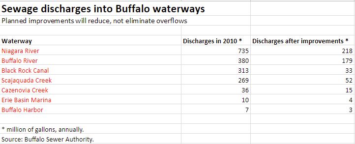
Pressed by the federal Environmental Protection Agency, the sewer authority is in the early stages of a 20-year, $380 million program to significantly reduce sewer overflows by at least two-thirds. The sewer authority has already completed about 35 projects in the past four years, reducing, but not eliminating, discharges into the Buffalo River, Black Rock Canal, Scajaquada Creek and Cazenovia Creek.
The authority estimates that a half-billion gallons of sewage and stormwater will continue to gush into creeks and rivers even after all of the work, involving some 75 projects, is completed in 2034.
“When we are done with this we will have reduced it so that it doesn’t have any effect on water quality,” said OJ McFoy, the general manager of the Buffalo Sewer Authority.
“That is the key thing: We will be in compliance with the Clean Water Act.”
In the meantime, local waterways continue to be inundated with discharges of sewage and stormwater runoff.
Sewer system woes
Negotiations between the Buffalo Sewer Authority and the EPA had dragged on for 15 years before the two agencies agreed on a plan in March 2014. At the time, President Obama’s top EPA administrator for the region that covers New York, Judith Enck, hailed the agreement as a “big victory” for Buffalo water quality and a “big deal for water quality in the Niagara River.”
EPA officials said the plan’s 20-year schedule recognized the severe economic challenges that Buffalo faces.
Investigative Post obtained the sewer overflow data from the Buffalo Sewer Authority’s Long-Term Control Plan, its blueprint for the $380 million of projects. That data, tabulated in 2010, is the most recent available and was used for the accompanying map.
Moderate to heavy rainfall can overwhelm wastewater treatment plants, which are designed to overflow sewage and stormwater runoff into lakes, creeks and rivers when capacity is reached. Illegal connections of downspouts to sewer lines and damage to underground sewer pipes also cause overflows.
From August to October of this year, Western New York communities reported at least 307 sewer overflows, according to state data reported under the Sewer Pollution Right to Know law. They include Buffalo, Cheektowaga, Kenmore, West Seneca, the Town and City of Tonawanda, Niagara Falls, Hamburg and Lockport. All of these communities are working to reduce sewer overflows, but the projects will take between five and 20 years to complete.
The waterways affected include, but are not limited to the Niagara and Buffalo rivers and the following creeks: Scajaquada, Two Mile, Ellicott, Cazenovia, Cayuga and Eighteen Mile in Lockport. The total volume of discharges is unclear because sewer operators sometimes provide incomplete or inaccurate information in the reports filed with state regulators.
Sewer overflows and runoff foul creeks and rivers with garbage and bacteria, including pathogens that can make people sick. State data shows sewer overflows and runoff are the chief reasons for beach closings along Lake Erie at places like Woodlawn and Bennett beaches.
Impact on popular spots
Black Rock Canal Park: The lion’s share of sewage and runoff discharged into the Niagara River – 601 million of 735 million gallons – flows from one point by the park near the foot of Ontario Street.

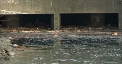
600 million gallons of sewage and stormwater spew from this tunnel by Black Rock Canal Park each year.
The wastewater enters the river a stone’s throw away from Aqua restaurant, Harbour Place Marina and a boat launch. During a visit by an Investigative Post reporter in August, garbage, dead fish and hundreds of cigarette filters littered the water near the park’s boat launch.
The discharge point is also about a mile upstream from Strawberry Island, a fish and wildlife preserve.
[nm-mc-form fid=”2″]
Work by the sewer authority will reduce overflows into the river to 206 million gallons – more than two-thirds – when completed in 2034. One major project is already completed, which stores in tanks and pipes underground up to a million gallons of sewage during rainfalls. After the rain stops, the wastewater is released for treatment at the Bird Island Wastewater Treatment Plant.
Broderick Park: Some 134 million gallons of raw sewage and stormwater a year is discharged into the Niagara River near Bird Island Pier, not far from Rich Products.
Frank Mancinelli, a regular fisherman at Broderick Park, said it is not uncommon to see toilet paper, condoms, and raw sewage in the river after moderate rainfall.
“The pollution is what’s killing the fish,” he said.
Work by the sewer authority will reduce the overflows to 11.7 million gallons, or 91 percent, when completed by 2026.
Red Jacket Park: About 124 million gallons of sewage and stormwater flow into the Buffalo River from this point at the foot of Smith Street in South Buffalo. The park features a popular kayak launch.
Work by the sewer authority will reduce the overflows to 29.6 million gallons, or 76 percent, when completed by 2024.
Mutual Riverfront Park: A fishing pier and kayak launch at the foot of Hamburg Street is near where 1.4 million gallons of wastewater is discharged annually into the Buffalo River. Discharges are expected decline to 1.2 million when work is completed.
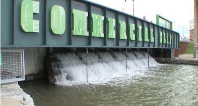
Canalside and Erie Basin Marina: About 70 million gallons of sewage gush into Canalside each year by the Buffalo and Erie County Naval and Military Park and Liberty Hound Restaurant. The sewer authority installed a boom to capture litter and debris. There is also a waterfall feature at the Commercial Slip that reduces odors and water stagnation. Discharges are scheduled to be cut in half when work is completed by 2032.
Next door, at the Erie Basin Marina, two-thirds of the 10 million gallons of discharge that found its way into the water has been have eliminated with new sewer lines and storage tanks.
Scajaquada Creek: One discharge pipe located in Forest Lawn Cemetery pours 268 million gallons of sewage and stormwater into the creek each year – on top of an estimated 300 million gallons reported upstream by Cheektowaga.
The sewage fouls the creek from the cemetery through Delaware Park before emptying into the Black Rock Canal, which is where crew teams practice. Sewer sludge is up to five feet deep in some of sections of the creek and the Avian botulism disease has killed hundreds, if not thousands of birds over the years.
The authority, in partnership with the cemetery and Buffalo Niagara Waterkeeper, are restoring sections of the creek from Main Street to Elmwood Avenue. In addition, the authority last year completed a project on Lang Avenue that’s designed to store up to 840,000 gallons of sewage when it rains.
In addition, the authority completed projects by Elmwood and Forest avenues with rain gardens and permeable pavement to soak up runoff and prevent it from entering storm drains.
Additional work by the sewer authority will reduce the overflows into Scajaquada Creek down to 53 million gallons a year, a reduction of more than three-quarters. All of the work in Buffalo is scheduled to be completed by 2030. But Cheektowaga, which is upstream of the Scajaquada, would need to make drastic reductions in its discharges for the creek to regain recover from the pollution.
The sewer overflows at each of these locations do not go unnoticed.
Jedlicka said her organization gets “lots of questions and complaints about the odors” from people visiting some of these parks and destinations.
“That’s the unfortunate thing, that some of the best public access points throughout Western New York are co-located to our stormwater and sewer outfalls,” she said.
The good news is the Buffalo Sewer Authority is on schedule.
The bad news is not everyone sees a difference yet.
“I wish they would let us know exactly what they’re doing and where because we really can’t see a difference,” said Koone, the fisherman at Mutual Riverfront Park.
In the meantime, the fish bite better some days than others.
Below is an interactive map that shows estimated discharges into city waterways before 2014 and reductions expected once the Buffalo Sewer Authority completes $380 million in sewer repairs by 2034. For the best results, click the double arrow box under the zoom box to expand the map.
How to use this map:
The bigger the bubble, the greater the volume.
Click on a bubble and you will see:
• Annual Volume MG (millions of gallons) is the annual estimated volume of sewer overflows before 2014.
• Frequency is the number of annual overflows before 2014.
• Annual Volume Goal MG (millions of gallons) is the estimated annual volume of overflows after Buffalo Sewer Authority fixes the sewer system within next 17 years.
• Frequency Goal is the estimated number of overflows annually after Buffalo Sewer Authority fixes the sewer system within the next 17 years.
• Receiving Waterbody is the waterway impacted by the sewer overflows.


